2.0 PURPOSE OF THE EMERGENCY ACTION PLAN (EAP)
2.1 Purpose
The purpose of this Emergency Action Plan (EAP) for Medina Lake Dam is to provide a systematic means to:
- Identify emergency conditions threatening a dam
- Expedite effective response actions to prevent failure
- Prevent or reduce loss of life and property damage should failure occur
By pre-planning the coordination of actions by the dam owner and responsible officials, timely notification, warning and evacuation can occur, which will help save lives and minimize property damage.
The Bexar-Medina-Atascosa counties Water Control and Improvement District No. 1, (BMA) owner of Medina Lake Dam has the responsibility for coordinating with federal, state, and local emergency action agencies to notify the public and to coordinate with the National Weather Service (NWS) during periods when a potentially hazardous situation is developing. Publication of this Plan is not intended to reflect in any way upon the integrity of Medina Lake Dam.
2.2 Importance of the Plan
Primary responsibility for inspection of Medina Lake Dam on a day-to-day basis rests with the Field Foreman employed by BMA. The Field Foreman is routinely advised by the BMA Board of Directors to observe the condition of the dam and to report any noticeable changes. During periods of high inflow to Medina Lake, the Field Foreman is advised to visually monitor and record changes in lake levels and to report unusual hydrologic conditions to the BMA Office. According to the Texas Water Commission’s Guidelines for Operation and Maintenance of Dams in Texas, [Ref 8]
- “On-Site” planning identifies responsibilities and tasks of the organization that operates the dam; explains how the dam will be operated under different kinds of emergency situations; lists what actions will be taken to identify, monitor, correct, and report potentially dangerous conditions; and also lists resources and capabilities to accomplish emergency tasks.
- “Off-Site” planning includes the identification of political jurisdictions potentially affected by a dam-related emergency; provides specific information concerning possible impact to each affected jurisdiction; includes detailed procedures for primary and alternate means for the dam owner to notify all affected jurisdictions of emergency situations and possible consequences; identifies organizations, responsibilities, resources, and capabilities to accomplish emergency tasks; and contains provisions for development, distribution, review, testing, and updating of all related emergency functions and procedures.
2.3 Chain of Command
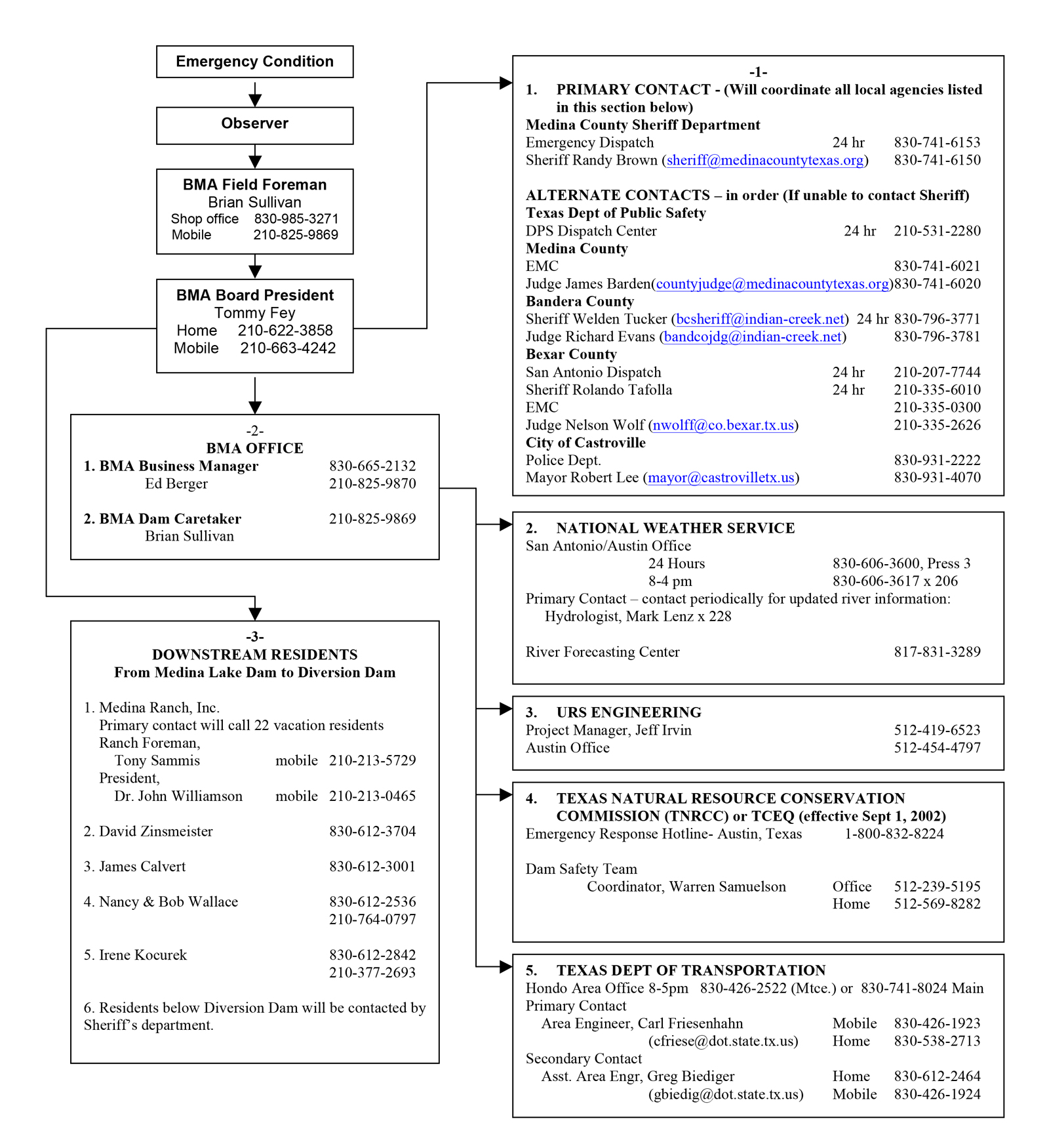
Following is a general sequence of staff positions through which notifications and instructions relative to an imminent or actual failure are to flow. The individuals currently assigned to these positions are listed by name on the NOTIFICATION FLOWCHART given in Section 1.
1. Field Foreman. This individual has the primary responsibility for:
a. Responsible for “On-Site” activities concerning the dam and associated structures;
b. The conduct of all inspections;
c. Reporting all significant occurrences to the President of the Board of Directors or Person in Charge;
d. Initiating loss prevention measures when the urgency of the problem precludes awaiting instructions before taking action; and
e. Implementing instructions received from the President of the Board of Directors or Person in Charge.
Should the Field Foreman be unavailable when an emergency situation develops, the following persons, in the sequence listed, shall assume the responsibilities of the Field Foreman as listed above:
- Business Manager;
- Board President; and
- Any member of the BMA Board of Directors.
2. Person in Charge. The President of the Board of Directors (Board President) is ultimately responsible for:
a. Actions of all BMA personnel;
b. Making determination of the course of action to be followed when time permits a deliberate consideration of the situation;
c. Directing the activity of BMA’s staff and other key personnel in implementing his decisions; and
d. Notifying & coordinating “Off-Site” jurisdictions and authorities when an emergency condition arises.
In the absence of the President, the following members of BMA’s staff, in the sequence listed, shall become the Person in Charge and shall assume the responsibilities of the President for directing activities necessary to deal with emergency situations:
- Any member of the BMA Board of Directors;
- Field Foreman; and
- Business Manager.
3.0 Project Description
A brief description of Medina Lake Dam is provided on the following pages. For more complete information on the entire project, reference should be made to the “Structural Stability Analysis for Medina Lake Main and Diversion Dams” dated March 1993 prepared by Blackwell Environmental, Inc. [Ref 2 from Inspection].
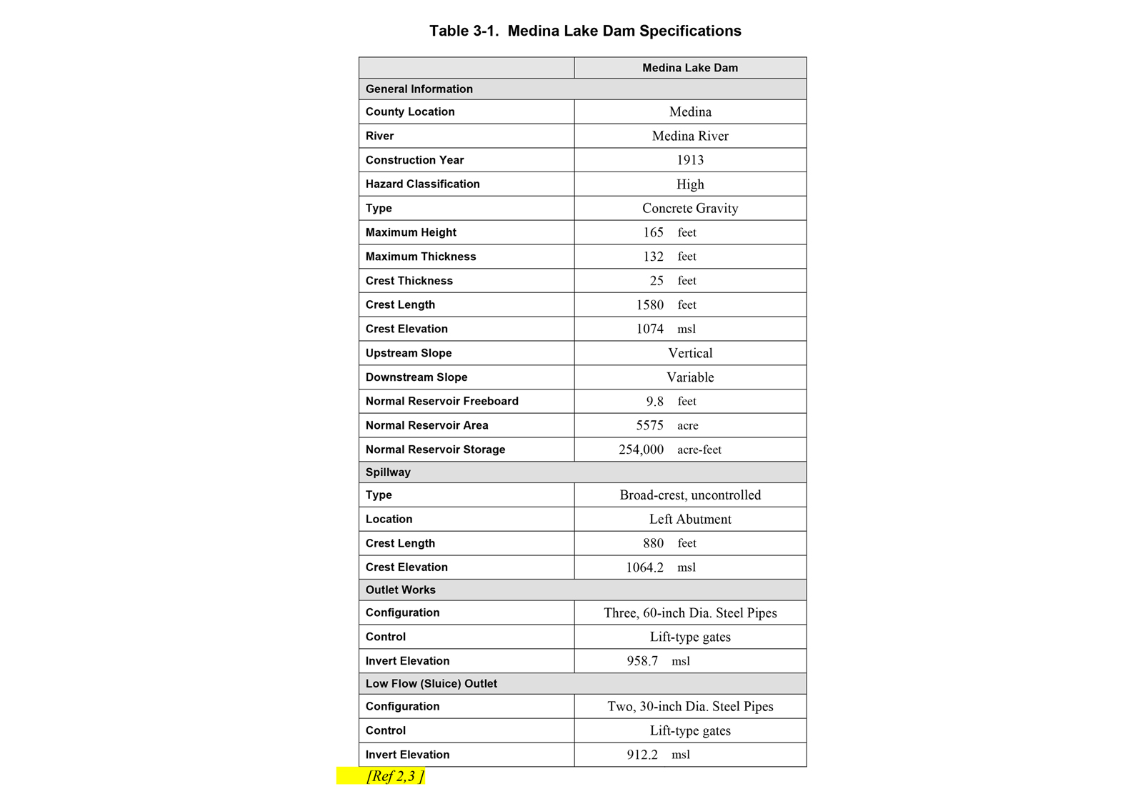
The Medina Lake Dam is located on the Medina River in Medina County, Texas, approximately 16 miles southeast of Bandera and about 27 miles northwest of San Antonio. A site location map is shown in Figure 3-1 [Ref 7]. The facility is owned and operated by the Bexar-Medina-Atascosa Counties Water Control and Improvement District Number 1. Both dams were constructed between 1911 and 1913 under the direction of Cr. F.S. Pearson, a consulting engineer from New York, who was an authority on the design and construction of dams in the early 1900s. The dam is a national registered landmark. Specifications for the Medina Lake Dam are summarized in Table 3-1.
3.1 Medina Lake Dam
The watershed of Medina Lake is comprised of approximately six hundred and thirty-four (634) square miles located in the Edwards Plateau Soil Conservation Service land resource area. Headwaters of the Medina River extend approximately forty-five (45) miles upstream from the lake beginning in moderately steep to rolling plains. The river flows in a generally southeasterly direction approximately thirty-six (36) miles to the City of Bandera, Texas, then travels southward approximately nine (9) miles to enter the headwaters of Medina Lake.
The typical cross section of Medina Main Dam consists of a vertical upstream face, crest thickness of 25 feet, and a variably sloping downstream face. The slope of the downstream face is vertical at the crest, then travels along the circle circumference with a radius of 80 feet from the crest to about elevation 1,046. The slope then continues along the circumference of a circle with a radius of 230 feet from elevation 1,046 to about elevation 970, and finally a constant slope of 0.93 (0.93H: 1V) from elevation 970 to the base of the dam. The maximum thickness at the base of the dam is about 132 feet [Ref 4 from Inspection].
The Main Dam has an uncontrolled spillway cut out of the limestone rock and located on the right abutment. The spillway crest is at elevation 1064.2 msl and has a crest length of about 880 feet. When the reservoir water surface level reaches the spillway crest elevation, the water flows over the crest and through the excavated saddle in the abutment rock. The reservoir then discharges into an adjacent ravine known as Mexican Creek. Medina Lake Dam is a concrete gravity dam with a crest length of 1,580 feet and maximum structural height of 165 feet. The crest of the dam is at elevation 1,074 ft mean sea level (msl). The base of the dam is at elevation 909 msl.
Medina Main Dam has two separate outlet work systems. The river outlet works consist of three 60-inch diameter outlets controlled by lift-type gates. The low level outlet works, which are for sediment control and reservoir evacuation, consist of two 30-inch diameter outlet pipes controlled by lift-type gates.
Normal maximum level of the Lake is at elevation 1064 ft msl which is the crest elevation of the uncontrolled spillway. The Bexar-Medina-Atascosa Counties Water Control and Improvement District No. 1 owns or controls all land upstream from Medina Lake Dam to elevation 1076 ft msl, thus providing twelve (12) feet of protection from flooding above normal maximum surface elevation. Numerous residential, recreational, and commercial developments have been built around the perimeter of the lake above the elevation 1076 ft msl high water line.
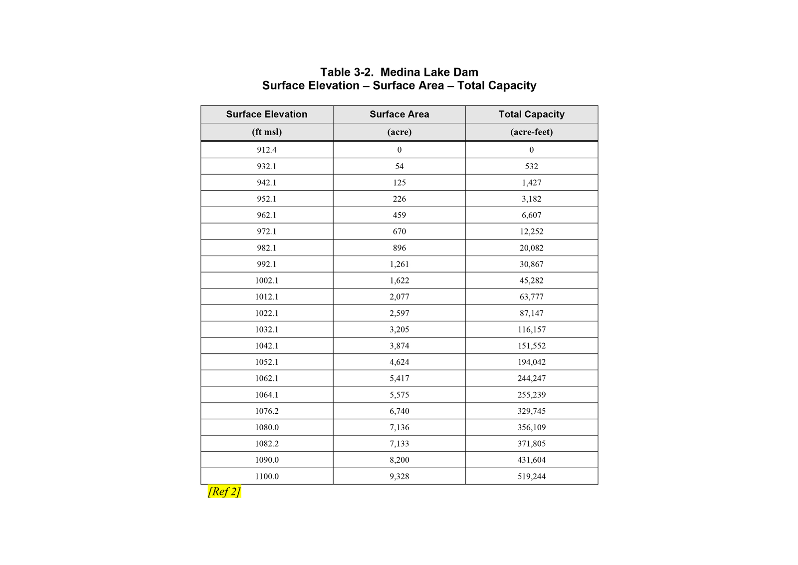
Table 3-2 shows the surface area and total capacity for several corresponding water levels. The maximum normal water surface level of Medina Lake is at elevation 1064 ft msl. Surface area of the reservoir at that level is approximately five thousand, five hundred and seventy-five (5,575) acres. Total capacity of the reservoir at that level is about two hundred and fifty-five thousand (255,247) acre-feet, all of which is used for irrigation conservation storage.
3.2 Downstream Information
Downstream from Medina Lake Dam, the river flows into the headwaters of Medina Diversion Lake, an impoundment approximately four (4) miles long, created by Medina Diversion Dam. Diversion Dam is a fifty (50) foot high, concrete gravity structure with an uncontrolled ogee-shaped crest and spillway owned and maintained by Bexar-Medina-Atascosa Counties WCID No. 1. From Diversion Dam, the river flows through a narrow limestone canyon with steep walls which rise generally several hundred feet above the river bed throughout a reach extending approximately seven (7) miles downstream from the Dam to the Community of Rio Medina. From Rio Medina the river continues southward through rolling plains and rural farmland approximately six (6) miles to the Town of Castroville. From Castroville, the river flows southeasterly approximately fifty-seven (57) miles to its confluence with the San Antonio River. Average slope of the river channel from Medina Lake Dam to its mouth is approximately seven and six tenths (7.6) feet per mile or fourteen hundredths (0.14) percent. A large portion of the stream flow is lost into the Edwards Aquifer and associated limestones in the Balcones Fault Zone.
Figure 3-1. Bexar-Medina-Atascosa WCID #1 Location Map
Reproduced from “Bexar-Medina-Atascosa Water Control and Improvement District Number 1, March 1999, Inspection of the Main and Diversion Dams.” Hearn Engineering, Inc. Round Rock, Texas.
Table 3-1. Medina Lake Dam Specifications
Table 3-2. Medina Lake Dam
Surface Elevation – Surface Area – Total Capacity
4.0 EMERGENCY CLASSIFICATIONS
4.1 Emergency Identification and Evaluation
Timely and reliable identification of emergency conditions at Medina Lake Dam is essential. The following conditions should be considered emergencies and will require the Field Foreman to determine the appropriate emergency classification. Incident report forms should be completed for any of the situations described below and kept in the BMA office.
4.1.1 Structural Problems
Structural problems include:
- Significant increases in or new seepage through horizontal lift lines;
- Significant increases in seepage through the abutment under constant lake water levels;
- Rock plucking or erosion within abutment due to seepage;
- Under low tailwater conditions, significant or unexplained increases in flow through drainage ports near inspection galleries;
- Visible movement at construction joints; or
- Significant or new cracking, slope movement, sinkholes, increased leakage, or muddy leakage found on the structures.
4.1.2 During Floods
When severe flooding of the reservoir is imminent, the Field Foreman shall visually monitor the structures on a continuous basis and operate Medina Lake Dam in accordance with operating procedures. Inspections should be conducted at least daily for a week after flood events.
4.1.3 After Earthquakes
The Field Foreman shall make a complete observation of the structures immediately after detection of an earthquake in the area. Inspections should be conducted at least daily for a week following an earthquake.
4.1.4 Failure
If a failure of either of the structures is noted, the Field Foreman shall immediately notify the appropriate officials in accordance with the notification flowchart.
4.1.5 Vandalism
Damage caused by vandalism shall be treated as Structural Problems.
4.2 Emergency Conditions
Once an emergency has been identified, it must be classified according to its urgency. The following four classifications shall be used. The table below includes several examples of condition marked “INTERIM GUIDANCE.” This interim guidance is in place arising from concerns expressed by the State Dam Safety Office during inspections of the dam during the Medina River flood in early July 2002. Further study to address State concerns is expected to result in a revision of the interim guidance below.
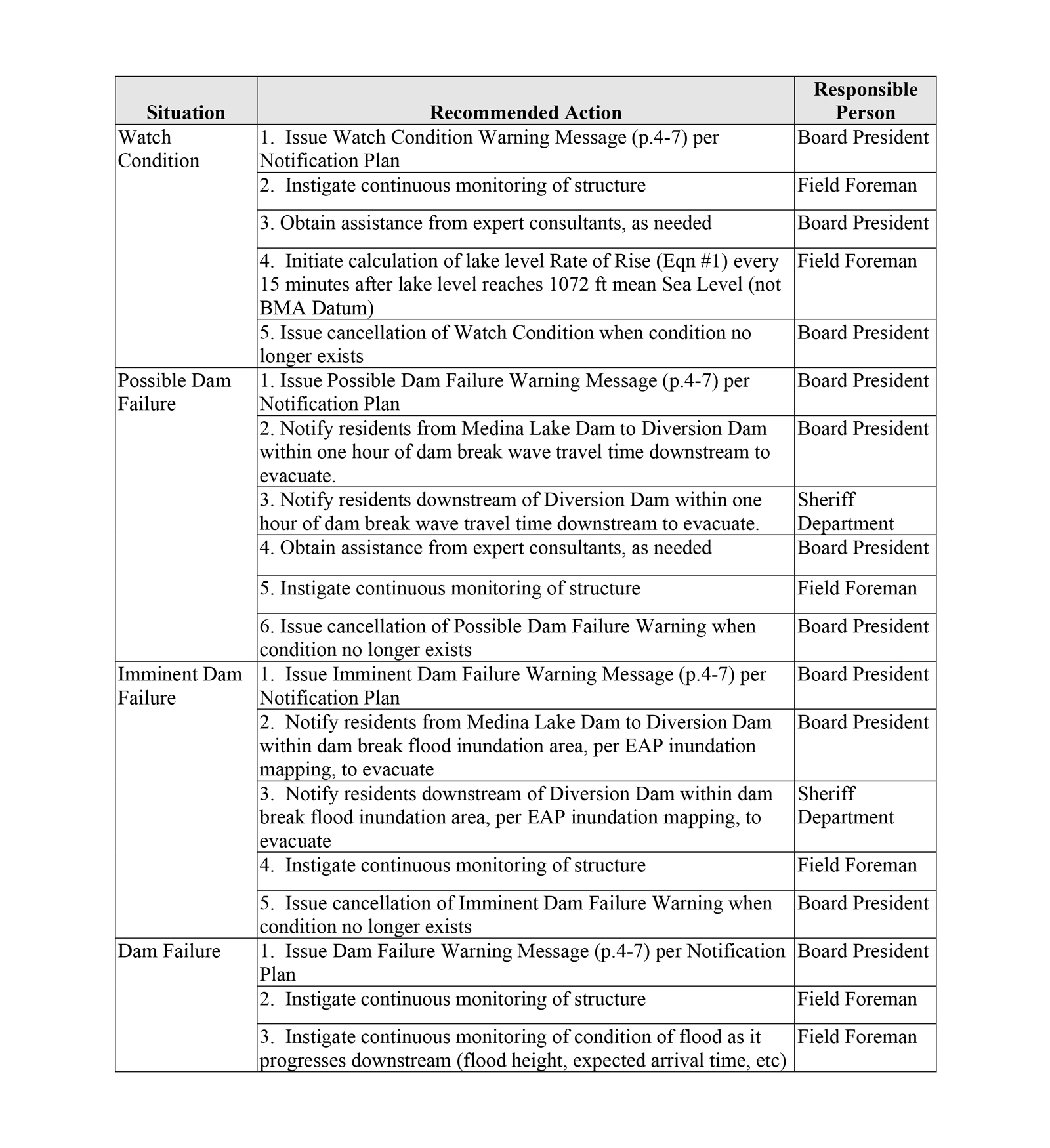
4.3 Emergency Actions
Once the emergency has been classified, the following actions are recommended.
4.4 Emergency Conditions Based on Water Levels – INTERIM GUIDANCE
Note: All other conditions of the Dam (structural, foundation, etc.) should also be monitored and evaluated with the water levels during an emergency situation. This table is consistent with the Table on page 4-2 and is intended as a further clarification of that table.
4.5 Water Level Rate of Rise Calculations
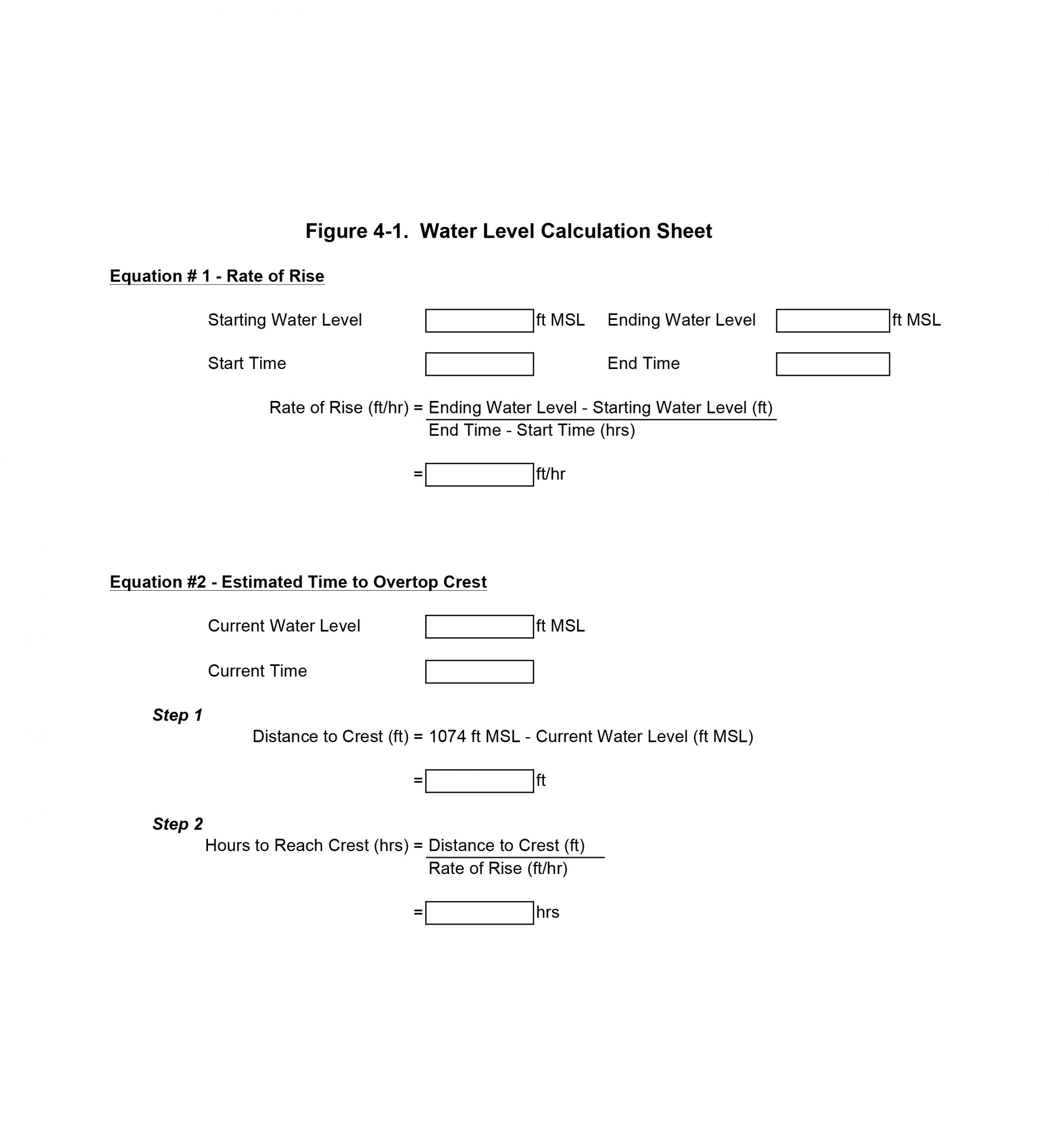
The Water Level Calculation Sheet shown in Figure 4-1 can be used as a reference to calculate water levels and predicted water levels. In order to calculate the Rate of Rise of the water level use Equation #1. To calculate the Estimated Time to Overtop Crest use Equation #2.
4.6 Water Level Monitoring Log
The Water Level Monitoring Log in Figure 4-2 can be used during an emergency to periodically record important information about the water levels, emergency condition status, rate of rise of the water level, estimated time to overtop crest, structural condition, and any other important comments.
4.7 Sample Notification Messages
WATCH CONDITION MESSAGE. THIS IS A DAM EMERGENCY MESSAGE. BEXAR-MEDINA-ATASCOSA COUNTIES WID #1 AT MEDINA LAKE DAM HAS DECLARED A WATCH CONDITION. (Briefly describe the problem/reason per Table 1). THERE IS NO IMMEDIATE DANGER OF THE DAM FAILING; HOWEVER, THE POTENTIAL DOES EXIST. REQUEST YOU INITIATE APPROPRIATE EMERGENCY MANAGEMENT PROCEDURES. FOR VERIFICATION, CALL THE PHONE NUMBERS LISTED ON PAGE 1-1 OF THE MEDINA LAKE DAM EMERGENCY ACTION PLAN. ADDITIONAL INFORMATION WILL BE PROVIDED AS IT BECOMES AVAILABLE.
POSSIBLE DAM FAILURE WARNING MESSAGE. THIS IS A DAM EMERGENCY MESSAGE. THE BEXAR-MEDINA-ATASCOSA COUNTIES WID #1 AT LAKE MEDINA LAKE DAM, HAS DELCARED A POSSIBLE DAM FAILURE WARNING CONDITION. (Briefly describe the problem/reason per Table 1). THERE IS A POSSIBILITY THAT THE DAM COULD FAIL PER INTERIM SAFETY GUIDELINES ESTABLISHED IN THE JULY 2002 FLOOD. REQUEST YOU INITIATE EMERGENCY MANAGEMENT PROCEDURES AND PREPARE FOR EVACUATION OF THREATENED AREAS. IF MEDINA LAKE DAM FAILS, FLOODING WILL OCCUR ALONG THE MEDINA RIVER. FOR VERIFICATION, CALL THE PHONE NUMBERS LISTED ON PAGE 1-1 OF THE LAKE MEDINA LAKE DAM EMERGENCY ACTION PLAN. ADDITIONAL INFORMATION WILL BE PROVIDED AS IT BECOMES AVAILABLE.
IMMINENT DAM FAILURE WARNING MESSAGE. URGENT!! THIS IS A DAM EMERGENCY MESSAGE. THE BEXAR-MEDINA-ATASCOSA COUNTIES WID #1 AT LAKE MEDINA DAM HAS DETERMINED THAT THE DAM IS IN IMMINENT DANGER OF FAILING PER INTERIM SAFETY GUIDELINES ESTABLISHED IN THE JULY 2002 FLOOD.. REQUEST YOU IMMEDIATELY INITIATE EMERGENCY MANAGEMENT PROCEDURES AND BEGIN EVACUATION OF THREATENED AREAS IMMEDIATELY DOWNSTREAM PER THE MEDINA LAKE DAM EMERGENCY ACTION PLAN. (If warning is issued based SOLELY upon potential for flow over crest, add: THIS WARNING IS BASED UPON THE POTENTIAL FOR THIS FLOOD OVERTOPPING THE DAM CREST AND NOT UPON IDENTIFICATION OF FAILURE CONDITIONS, AND THEREFORE EVACUATION IS ONLY PLANNED AT THIS TIME FOR AREAS IMMEDIATELY DOWNSTREAM OF THE RESERVOIR PER THE MEDINA LAKE DAM EMERGENCY ACTION PLAN.). IF MEDINA LAKE DAM FAILS, A FLOOD WAVE WILL MOVE DOWN THE MEDINA RIVER THROUGH CASTROVILLE AND LA COSTE, AND ON DOWN THE RIVER. FOR VERIFICATION, CALL THE PHONE NUMBERS LISTED ON PAGE 1-1 OF THE MEDINA LAKE DAM EMERGENCY ACTION PLAN.
DAM FAILURE MESSAGE. EMERGENCY! THIS IS A DAM FAILURE EMERGENCY MESSAGE. THIS IS THE BEXAR-MEDINA-ATASCOSA COUNTIES WID #1, MEDINA LAKE DAM HAS FAILED. A FLOOD WAVE IS NOW MOVING DOWN THE MEDINA RIVER AND THE PEAK WILL REACH (list prominent points and the time to reach them, per travel times in Emergency Action Plan). EVACUATE THREATENED AREAS IMMEDIATELY. FOR VERIFICATION, CALL THE PHONE NUMBERS LISTED ON PAGE 1-1 OF THE MEDINA LAKE DAM EMERGENCY ACTION PLAN.
5.0 RESPONSIBILITIES UNDER THE EAP
5.1 General
The EAP provides procedures which facilitate the prevention and management of an emergency at Medina Lake Dam and outlines specific responsibilities of local, state, and government authorities.
5.2 Notification Flowchart – Figure 1-1
The Emergency Notification Flowchart for Medina Lake Dam is depicted in Section 1. This flowchart lists the agencies who will be notified in the event of an actual, imminent, or potential dam failure and who is responsible for contacting these agencies. Information is exchanged both up and down the notification flowchart during the emergency notification process.
5.3 Identification And Evaluation – Dam Owner – BMA
The dam owner, BMA, is responsible for designating a Field Foreman who has specific responsibility for ensuring Medina Lake Dam are inspected regularly. The Field Foreman is responsible for identifying and evaluating the seriousness of any abnormalities associated with the structures either during a routine or special inspection and discussing these with the Board President. In order to predict future flood and water level conditions, contact should be made to the National Weather Service – San Antonio/Austin Office Hydrologist.
5.4 Initial and Update Notifications – Dam Owner – BMA
As shown in the emergency notification flowchart, the Board President is responsible for the initial notification of a potential or actual emergency condition. As soon as an emergency situation develops, the Board President will contact Medina County Sheriff’s Department and the National Weather Service (NWS). The Sheriff will then implement the communications portion of the County’s Emergency Plan and the NWS will update or issue any emergency flood warnings. The Board President shall also update the Sheriff’s Department with notifications of changes in dam conditions and/or any changes to the declared emergency condition.
5.5 Notice To Evacuate – Medina County Sheriff Department
Warning and notice to evacuate are the responsibility of the Medina County Sheriff. Once the Medina County Sheriff’s Department receives notice of an impending emergency, it will implement the communications portion of the County’s Emergency Plan. Initiating this plan involves notifying Emergency Management Coordinator (EMC) personnel from Medina County and the Cities of Rio Medina and Castroville. EMC personnel from these jurisdictions will then contact their respective police and fire departments to initiate street-level evacuation if necessary. The flood inundation maps provided in Section 7 of this document will assist emergency personnel in knowing which residences and properties to evacuate.
5.6 Termination And Follow-up – Medina County Office Of Emergency Management
The Emergency Management Coordinator with the Medina Office of Emergency Management will be responsible for determining when the emergency is over. After the emergency, EAP team members will meet, evaluate the process, and discuss their evaluations in a written report.
5.7 EAP Coordinator Responsibility – Dam Owner – BMA
The BMA Business Manager will be responsible for coordinating those activities discussed in Appendix C, Training, Exercising, Updating, and Posting the EAP, and shall act as the point of contact for any matters concerning this EAP.
6.0 EMERGENCY PREPAREDNESS
6.1 General Provisions for Preparedness
All employees at the Dam should be constantly alert during their routines to observe any change which might indicate a potential problem. Any change thus observed shall be promptly reported to the Field Foreman who will conduct a special inspection of the observed change and complete a Special Inspection Report generally in the form attached as Appendix F. The collection of all factual and technical information is imperative, and photographs are highly desirable.
Visual evidence of potential problems would include
- Significant increases in or new seepage through horizontal lift lines;
- Significant increases in seepage through the abutment under constant lake water levels;
- Rock plucking or erosion within abutment due to seepage;
- Under low tailwater conditions, significant or unexplained increases in flow through drainage ports near inspection galleries;
- Visible movement at construction joints; or
- Significant or new cracking, slope movement, sinkholes, increased leakage, or muddy leakage found on the structures.
The Field Foreman will be responsible for the conduct of formal inspections on a routine basis at monthly and yearly intervals. Any potential problem detected during the inspection shall be immediately reported by telephone to the Board President or Person in Charge and the problem, plus any corrective actions taken, shall be described in a written report to the Board President within 10 days of the inspection. A list of the items to be specifically inspected at the time intervals indicated is attached as Appendix E.
At five-year intervals, a complete safety inspection of the Dam and appurtenances will be made, and a comprehensive written report will be prepared by BMA’s Consulting Engineer. Copies of that report will be furnished to the Texas Natural Resource Conservation Commission’s Dam Safety Office.
6.2 Communications
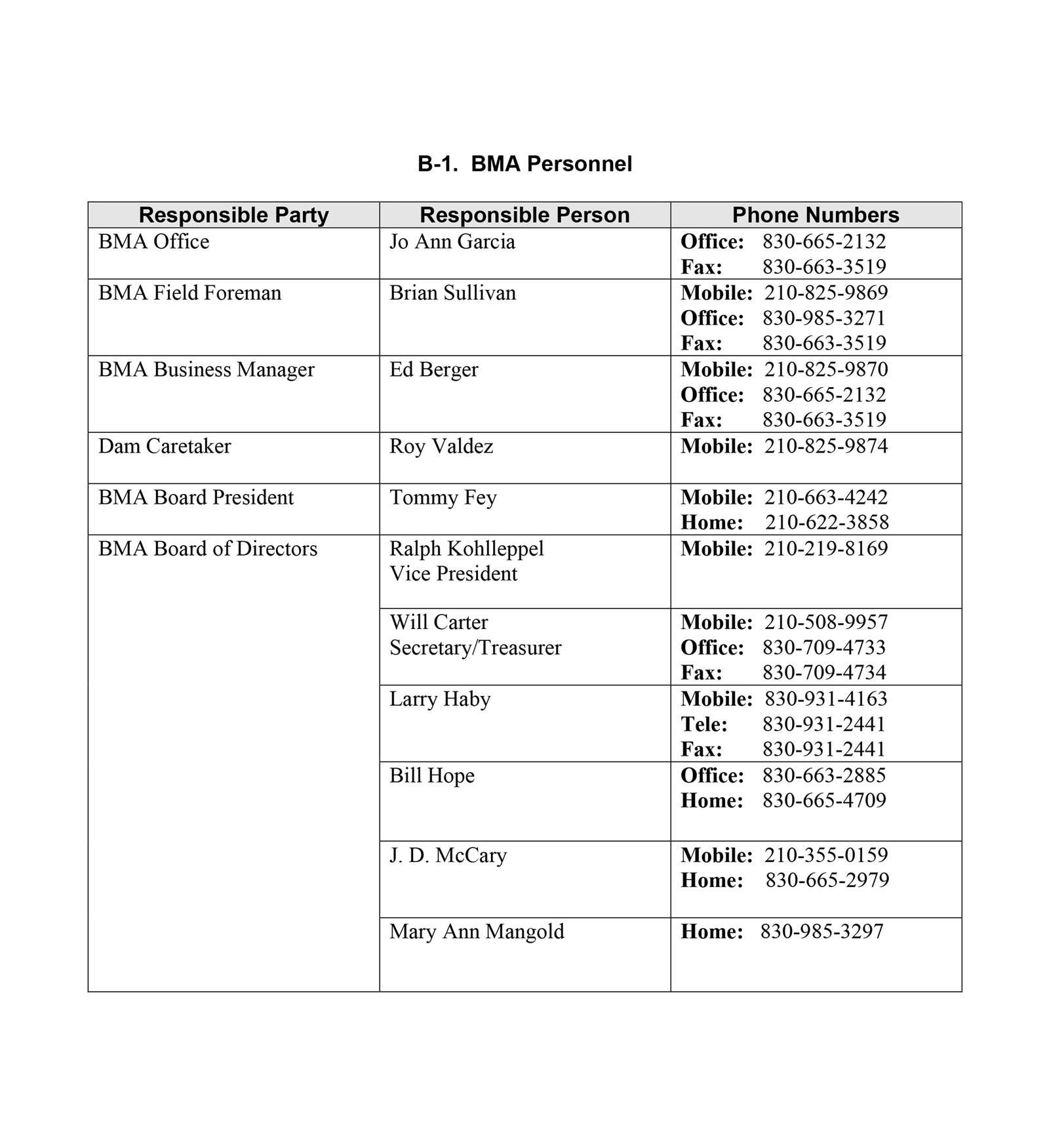
The primary means of communication for BMA to notify emergency personnel according to the flowchart shall be telephone. A complete listing of both office and home telephone numbers of the members of the BMA’s staff that may need to be contacted in the event of an emergency situation is included in Appendix B-1.
The secondary means of communication for BMA shall be by radio. In the event telephones are inoperable, or inefficient, radio will be used as a backup. The various radio nets which are available for this type of emergency use are:
- Sheriff’s Department of each county;
- Texas Department of Public Safety;
- State Department of Highways and Public Transportation; and
- Ham radio.
Methods of communication for the Medina Sheriff Department, outlined in the Medina County EMC Emergency Plan, will be used to notify and evacuate those residences and properties downstream of Diversion Lake Dam identified on the inundation maps.
6.3 Equipment
The Medina County EMC is responsible for coordinating the acquisition of equipment and resources during an emergency situation; such measures are in accordance with the County’s Emergency Plan.
Equipment which may be required in the event of an emergency include a track hoe to remove debris from the structures, or a floodlight with a gas operated generator for night-time inspections.
The following equipment is property of BMA and is stored at the Pearson Lake Canal (Main Canal) Shop:
- EL 240B Excavator;
- 225 Excavator;
- D 4 H Dozer;
- 418 B Backhoe;
- 120 G Motor Grater;
- 6610 A Ford Tractor;
- 6610 B Ford Tractor;
- T N 55 Ford Tractor;
- 4500 John Deere Tractor;
- 01 Ford Crew Cab 8 Cyl.;
- 01 Ford Ranger 4 Cyl.;
- 00 Ford Ranger 4 Cyl.;
- 00 Ford Ranger 4 Cyl.;
- 00 Ford Ranger 4 Cyl.;
- 94 Ford Ranger 4 Cyl.;
- 88 Dodge 8 Cyl.;
- 86 Dodge 8 Cyl.;
- 83 Dodge 8 Cyl.; and
- 79 Auto Car Haul Truck.
Additional emergency supplies and assistance for flood victims will be solicited from the American Red Cross and the Salvation Army, both located in San Antonio, Texas.
6.4 Accessibility to Medina Lake Dam
Access to the dam is available the east side of the dam. In the event of an emergency, the dam can be accessed _____________[information to be added]_________________________.
6.5 Response During Periods of Darkness
In addition to overhead spotlights mounted on BMA vehicles, assistance will be sought from Bandera Electric Cooperative, Inc. to provide line crew vehicles with high intensity spotlights which will enhance nighttime observation of the Dam. Access for making observations will be from the utility right-of-way access road along the left bank near the left abutment of Medina Lake Dam.
6.6 Inspections Following Extraordinary Events
Extraordinary events which must routinely be followed at the earliest practical time by an inspection include but are not limited to a flood passage, earthquake, or explosion. Any other happening about which there is any doubt will be considered as an extraordinary event.
In the inspections conducted subsequent to extraordinary events, specific attention will be given to those items so indicated on the Routine Inspection Schedule attached as Appendix E.
Evidence of any damage shall immediately be reported by telephone to the Board President or Person in Charge. The Field Foreman shall document in writing and with pictures, if possible, the damages observed so that any change in conditions can be determined at any time. He will also submit to the President at the earliest practical time, a written report of pertinent information including but not limited to a description of the event, the extent and location of the observed damage, the date, time, lake elevation, weather conditions, immediate and potential effect of the damage, and remedial actions taken or recommended to be taken.
7.0 INUNDATION MAPS
Inundation maps for Medina Lake Dam are included in the following pages. These inundation maps were derived by Willard-Swift Engineers [Ref 3] in 1988. At the time of publication of this DRAFT EAP, a copy of this report has not been located. It is understood that the clarity of inundation maps available for use in this DRAFT Plan is poor. Until such time as better quality maps are located or the study is redone, the boundaries of potential inundation should be interpreted conservatively from the available mapping (i.e. in areas where the inundation boundary is uncertain, all populated areas should be notified).
The maps show the locations of residences and properties that will need to be evacuated in the event failure of either structure is imminent. The inundated areas are shown on three maps and the areas for each map are listed below:
- Figure 7-1 – Medina Lake Dam to Castroville;
- Figure 7-2 – Castroville to La Coste; and
- Figure 7-3 – La Coste to Lackland AFB.
The areas that would be inundated are based upon instantaneous breaching of Medina Main Dam during fair weather conditions (no inflow), which is the model scenario that is generally considered by the Federal Energy Regulatory Commission (FERC) to have the most potential for loss of life. Appendix D shows details of the Dam Breach Analysis and a summary of results from the model. Per this appendix, the mapping in this section is based upon an “instantaneous break” of the dam.
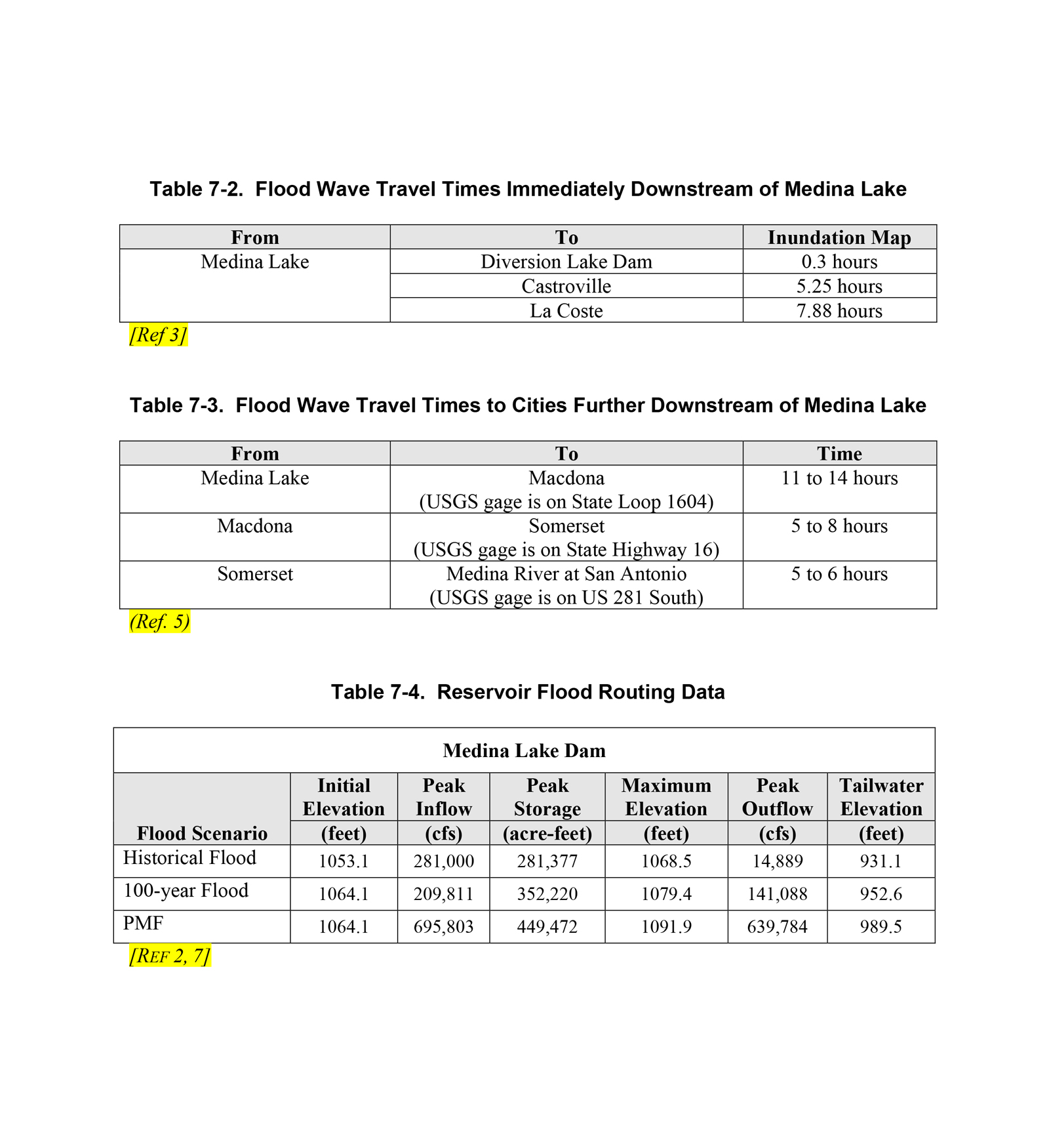
The flood wave travel times upstream from the USGS Gage at Bandera, listed in Table 7-1, is 5-6 hours based on a flow rate of 100,000 cfs. Flood wave travel times downstream are shown in Tables 7-2 and 7-3. Table 7-4 shows the reservoir flood routing data including the initial elevation, peak inflow, peak storage, maximum elevation, peak outflow and tailwater elevation for several flood conditions.
8.0 REFERENCES
- Bexar-Medina-Atascosa Water Control and Improvement District Number 1, Emergency Action Plan for the Medina Lake Main Dam. Blackwell Environmental, Inc., January 31, 1994.
- Safety Inspection for Medina Main and Diversion Dams, Medina County, Texas. URS Corporation, Austin, Texas, April 2002.
- Dam Breach Analysis. Willard-Swift Engineers, Inc. (Current company name is Guy Engineering Services) Tulsa, Oklahoma. September 1988.
- Possum Kingdom Emergency Action Plan. December 28, 2001.
- National Weather Service, Nezette Rydell, Hydrologist, Email dated August 1, 2002 to URS, Austin, Texas.
- Engineering Guidelines for the Evaluation of Hydropower Project. Federal Energy Regulatory Commission, July 7, 1988. [Ref 16 from Inspection]
- Bexar-Medina-Atascosa Water Control and Improvement District Number 1, March 1999, Inspection of the Main and Diversion Dams. Hearn Engineering, Inc. Round Rock, Texas.
- Guidelines for Operation and Maintenance of Dams in Texas. Chapter 8: Emergency Action Plan Guidelines. Texas Water Commission, September 1990.
We understand the importance of this document and its intent to protect lives in the event of an emergency. We understand our roles and responsibilities as outlined in this EAP and our signatures below indicate approval and acceptance of this EAP.
B-2. Primary Emergency Contacts
County Officials
PRIMARY CONTACT – (Will coordinate all local agencies listed in this section below)
- Medina County Sheriff Department
Emergency Dispatch 24 hr 830-741-6153
Sheriff Gilbert Rodriquez 830-741-6151
ALTERNATE CONTACTS –
in order (If unable to contact Sheriff)
- Texas Dept of Public Safety
DPS Dispatch Center | 24 hr 210-531-2280
- Medina County
EMC | 830-741-6021
Judge David Montgomery | 830-741-6020
- Bandera County
Sheriff James MacMillan | 24 hr 830-796-3771
Judge Richard Evans | 830-796-3781
- Bexar County
San Antonio Dispatch | 24 hr 210-207-7744
Sheriff Ralph Lopez | 24 hr 210-335-6000
EMC | 210-335-0300
Judge Nelson Wolf | 210-335-2626
- City of Castroville
- Police Dept | 830-931-2222
- Mayor Robert Hancock | 830-931-4070
II. Federal and State Officials
- NATIONAL WEATHER SERVICE
- San Antonio/Austin Office
24 Hours – 830-606-3600, Press 3
8-4pm – 830-606-3617, x206
Primary Contact – contact periodically for updated river information –
Hydrologist, Nezette Rydell x228 - River Forecasting Center – 817-826-4679
- San Antonio/Austin Office
- TEXAS NATURAL RESOURCE CONSERVATION COMMISSION (TNRCC) or
TCEQ (effective Sept 1, 2002)
- Emergency Response Hotline- Austin, Texas – 1-800-832-8224
- Dam Safety Team – Coordinator, Chau Vo
Office 512-239-4763
Home 512-259-9290
- TEXAS DEPARTMENT OF TRANSPORTATION
- Hondo Area Office – 8-5pm | 830-426-2522 or 830-741-8024
Primary Contact – Area Engineer, Carl Friesenhahn
Mobile 830-426-1923 | Home 830-538-2713 - Secondary Contact – Asst. Area Engineer, Greg Biediger
Home 830-612-2464
- Hondo Area Office – 8-5pm | 830-426-2522 or 830-741-8024
B-3. Downstream Residents
- Medina Ranch, Inc. (Primary contact will call 22 vacation residents.)
- Ranch Foreman, Tony Sammis | Mobile 210-213-5729
- President, Dr. John Williamson | Mobile 210-213-0465
- James Calvert | 830-612-3001
- Nancy & Bob Wallace | 830-612-2536 | 210-764-0797
- Irene Kocurek 830-612-2842 | 210-377-2693
- Residents below Diversion Lake Dam will be contacted by the Sheriff’s Department and Department of Public Safety. David Zinsmeister 830-612-3704
B-4. Secondary Emergency Contacts
-
Alternate Communications
- Medina County Amateur Radio
8222 FM 471 S
Castroville, TX 78009
(830) 931-3307
- Medina County Amateur Radio
-
News Media
- Channel 4 – KMOL TV, San Antonio
210-226-5665 - Channel 5 – KENS TV, San Antonio
210-366-5000 - Channel 12 – KSAT TV, San Antonio
210-226-7611 - Channel 29 – KABB , San Antonio
210-442-6397 - KISS – FM 99.5, San Antonio
210-223-6211 - KHCL – AM, Highway 173
210-796-3033 - KTXX – AM, Devine
210-663-4456 - KRME – AM, Hondo
210-426-3367 - KTSA – 550 AM, San Antonio
210-599-5195
- Channel 4 – KMOL TV, San Antonio
-
Red Cross
- The Red Cross is normally notified through DPS. If DPS cannot be notified and the situation will require Red Cross services, proceed as outlined below.
- Chapter officials would need to have the following information:
- Type of problem to expect.
- When to expect it.
- How long conditions could last.
- Areas to be affected.
B-5. Consultants and Other Specialists
-
Structural
- Guy S. Lund, P.E. | URS Corporation
Phone: 303-740-3902 (direct) | 303-694-2770 (main office)
- Guy S. Lund, P.E. | URS Corporation
-
Geotechnical
- Colin Young, P.E. | URS Corporation
Phone: 512-419-5903 (direct) | 512-454-4797 (main office)
- Colin Young, P.E. | URS Corporation
-
General
- Jeff Irvin | Project Manager | URS Corporation
Phone: 512-419-6523 (direct) | 512-454-4797 (main office)
- Jeff Irvin | Project Manager | URS Corporation
-
Land Surveying
- Harlan Wolff Land Surveying
918 18th Street | Hondo, TX 78861
Phone: 830-741-4844
- Harlan Wolff Land Surveying
-
Legal Services
- Patrick W. Lindner, Attorney-at-Law | Davidson & Troilo, PC.
7550 W. IH-35, Suite 800 | San Antonio, TX 78229-5815
Phone: 210-349-6484
- Patrick W. Lindner, Attorney-at-Law | Davidson & Troilo, PC.
Training, Exercising, Updating, and Posting the EAP
The BMA Business Manager will be responsible for coordinating the Training, Exercising, updating, and Posting of the EAP. The Business Manager will also act as the point of contact for any matters concerning the EAP.
Training
Training of personnel responsible for implementing the EAP will be conducted on an annual basis. The training will provide new personnel with an opportunity to become intimately familiar with the plan and serve as a refresher for those personnel already trained. The training will include problem detection and evaluation, and emergency response. Exercises will be conducted as part of the training to help ensure that those personnel involved in implementing the EAP understand their respective roles and responsibilities. A more detailed discussion of the exercise program is discussed below. The dam owner will be responsible for organizing the training. However, EAP team members are responsible for notifying the dam owner if they believe training is necessary sooner than the scheduled training event due to changes in the plan.
EAP Exercise Program
The Business Manager will organize a training and exercise program for Medina Lake Dam, a minimum of once per year. The program will include of time to address the following items:
- How to use the plan
- How to identify problems and their severity
- How to use the notification procedures and the communication equipment
- What resources are available
- The importance of their role during emergencies
- The importance of updating downstream information
- Any additional topics of importance regarding an emergency situation.
All residences and businesses in the inundation zone should be advised of the potential need for evacuations and the actions they should take in such an event. This must include evacuation routes (away from the danger zone) to be taken.
Updating the EAP
The Business Manager should be promptly notified of changes in the following:
- Contacts (especially those having notification responsibilities);
- Telephone numbers;
- Communication systems;
- Floodplain; and
- Medina Lake Dam.
The Business Manager shall make necessary changes and promptly distribute revisions of the EAP to all those responsible for implementing the EAP.
At a minimum, the EAP will be reviewed annually to ensure workability, efficiency (timeliness), and to identify and improve any weak areas. The EAP will also be reprinted and redistributed in its entirety every 5 years.
Posting EAP
Updated copies of the EAP will be kept in the following locations:
- BMA Office;
- BMA Dam Field Office;
- Medina County Sheriff Department;
- Medina County, Office of Emergency Management;
- Bandera County Sheriff Department;
- Bexar County Sheriff Department;
- Bexar County, Office of Emergency Management;
- City of Rio Medina, Office of Emergency Management;
- City of Castroville, Office of Emergency Management;
- National Weather Service, San Antonio/Austin Office
- TNRCC, Dam Safety Office;
- Texas Department of Transportation, Hondo Area Office;
- Texas Water Commission;
- Texas Department of Public Safety, Division of Emergency Management; and
- URS Corporation, Austin Office.

