Medina Lake OSSF updated study by URS
1.0 INTRODUCTION
In 2004 URS carried out a study for the Bexar Medina Atascosa Water District (BMA) in order to identify properties which were likely to have on-site sewage facilities (OSSFs). These properties, if built after 1997 would be required to comply with regulation governing the construction and maintenance of OSSFs in Texas. The study was commissioned following a rise in fecal coliform levels in Medina Lake and concern from BMA that OSSFs were a potential source of contamination of the lake.
This memorandum presents an updated estimate of the number of potential OSSFs located around Lake Medina, using a similar GIS-based methodology to that used in 2004. The following sections outline relevant background information and the study approach, and are followed by a brief discussion of structure counts. To accompany this memorandum, a map book (including 28 maps) showing potentially relevant structures was also created as an update to the report submitted to BMA in 2004.
1.1 Background Information on OSSF Regulation Results of Previous Study
OSSFs are currently regulated by the Texas Commission on Environmental Quality (TCEQ). While OSSF regulation has been in place since 1987, systems installed before 1997 are largely exempt from these rules due to grandfathering allowances. This is not the case, however, for systems that have been altered and/or are in need of substantial repair.
In addition to permitting rules, for OSSFs not grandfathered the following siting requirements apply in the area around Lake Medina:
1. Septic tanks should be set back 75 feet from the “normal pool elevation and water level” for a lake (50 feet for septic fields)
2. Installed systems should have at least two feet of soil beneath them (to either a restrictive horizon or groundwater)
3. For OSSFs installed within the 100-year floodplain, a professional engineer must demonstrate that (i) the OSSF will not increase the height of the flood, (ii) the system should be buried without adding fill (with the exception of some components such as risers and sprinklers, which should be elevated above the 100-year floodplain)
1.2 Results of Previous Study
The study undertaken in 2004 used a detailed GIS analysis methodology to estimate the number of OSSFs sited around Medina Lake. This involved (i) building a spatial database of structures and areas of interest around Medina Lake (including structures within the normal pool contour and regulatory floodplain), (ii) querying the number of structures or parcels within these areas of interest and (iii) reviewing a sample of OSSF permit applications and permits from relevant property owners.
Results of the previous study indicated that more than 500 OSSFs exist both within 100 feet of the normal level of Medina Lake and on shallow soils. The permit survey was less conclusive, though permits reviewed showed awareness of the siting requirements for OSSFs as set out in the Texas Administrative Code (TAC).
2.0 METHODOLOGY
This memorandum follows a methodology similar to the 2004 URS study, making use of the most recent data and imagery available. The study area for this analysis includes land contained between contours at the 100yr floodplain elevation and the normal pool elevation for Medina Lake (shown in the associated maps). The following steps were taken in order to (i) update and verify relevant source data and (ii) estimate relevant structure counts.
2.1 Verification of OSSF regulation
OSSF rules within the TAC were checked for changes made to relevant legislation since 2004. However, no changes pertinent to the present study were found. In particular, no rule changes relevant to OSSFs sited near lakes or in regulated floodplains have been made since the previous study was undertaken.
2.2 Data Collection and Update
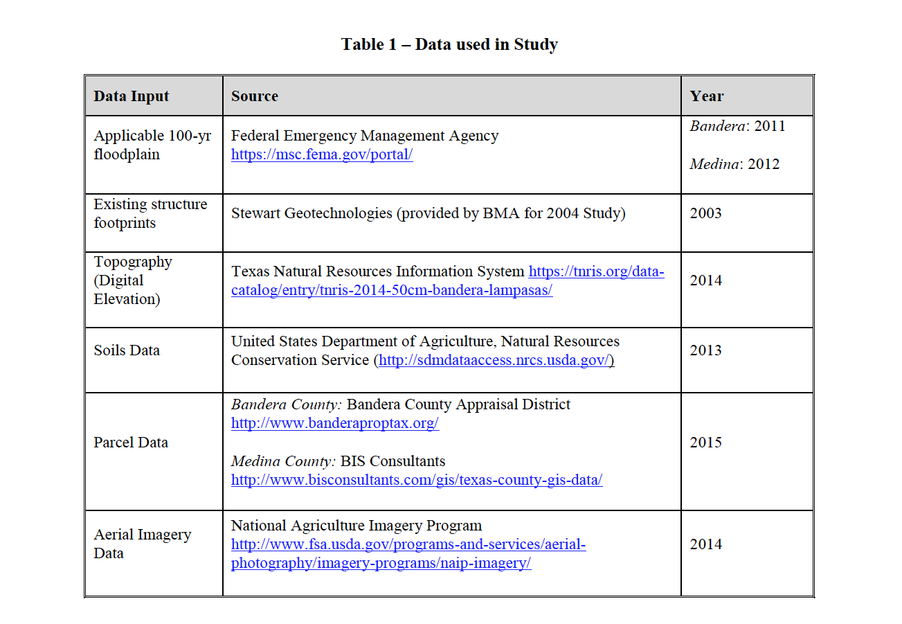
In order to update the structure counts, the datasets shown in Table 1 were obtained and/or verified.

2.3 GIS Analysis and Structure Counts
In order to estimate potential OSSF counts within the study area, the following tasks were completed:
1. The study area was determined by querying and including parcels within 475 feet of the normal pool level of Medina Lake (1072 foot contour)1
2. Parcels were reviewed for structures using the most recent available aerial imagery (NAIP, 2014; checked against Google imagery). Parcels containing no structures were discarded.2
3. Structure footprints were deleted, added or amended according to the aerial imagery within included parcels as necessary to update the 2004 structure dataset.
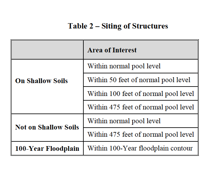
4. Areas of interest were created around Medina Lake, as shown in Table 2 below, by combining the following data:
i. Soils around Medina Lake were classified as ‘shallow’ (less than two feet to bedrock) and ‘not shallow’ (more than two feet to bedrock) according to the classification used previously3
ii. Normal pool contour; obtained from 2014 digital elevation model at an elevation of 1072 feet (local datum).
iii. 100-year floodplain (as obtained from FEMA)
5. Structure footprints were spatially queried against areas listed above in order to assign each structure an ‘area of interest’ (e.g. ‘on shallow soil, within 50 feet of normal pool level’)
6. Parcels were spatially queried against structures contained within them, and assigned the ‘area of interest’ corresponding to the lowest structure. Each parcel was assigned only one area of interest.4
1 As in the 2004 study, this extent was chosen to represent 400 feet from the 75 foot set back rule for OSSFs; this distance is based on the previous assumption that septic systems are found downhill from structures by at least one foot of elevation change
2 Small structures (e.g. sheds, garages, etc.) were removed from the building footprint database
3 For Bandera County: Brackett (map symbols BKX, BRX), Doss (DS), and Tarrant (TBX, TDX, TRX, TSX); and for Medina County: Brackett (map symbols BKD, BRF), Speck (SPD), and Tarrant (TAD, TAF, TBG)
4 Only one structure was included per parcel, with exceptions for large, multi-structure parcels where multiple OSSFs would be feasible. It is assumed that parcels, in general, only contain one OSSF within this study area.

3.0 RESULTS
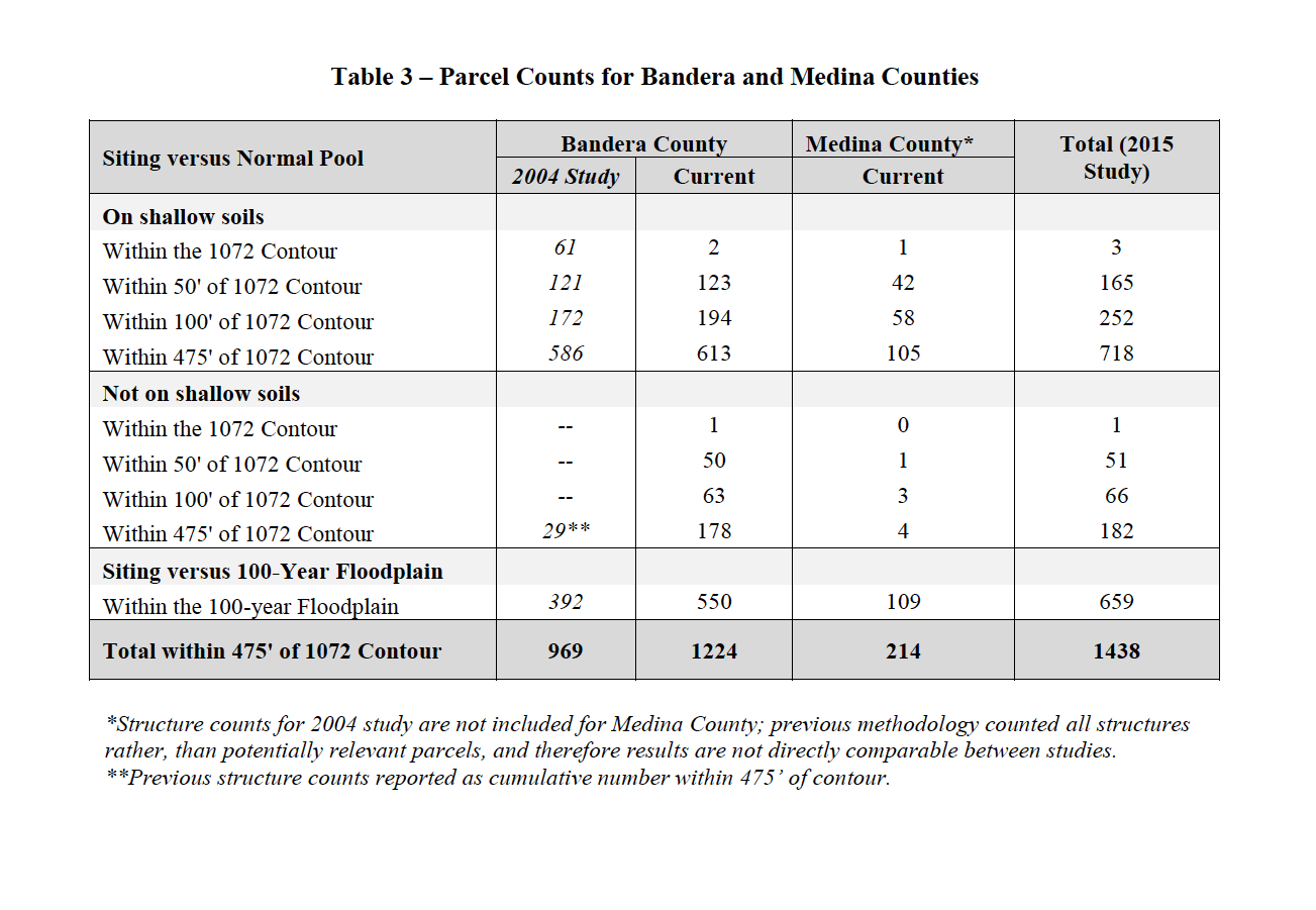
The results of the potentially relevant property counts for both Bandera and Medina Counties are shown in Table 3 below, according to ‘area of interest.’ An estimate of the number of properties containing OSSFs across both counties is 1438. Potentially relevant structures on these properties are shown in the map book associated with this report.
3.1 Normal Pool Siting Requirement
As shown, overall the parcel count is substantially larger for Bandera County compared to the study undertaken in 2004 (1224 compared to 969, an increase of approximately 26 percent). However, a large decrease in the number of structures sited within the normal pool level is seen; this is most likely explained by the stricter criteria for inclusion of structures and parcels in this study.
3.2 Floodplain Siting Requirement
Estimates of the number of parcels with structures located within the 100-year floodplain (subject to stricter siting requirements as outlined above) in Bandera and Medina Counties are 550 and 109, respectively.
3.3 Shallow Soils Requirement
The majority of structures and parcels in both counties of interest are found on shallow soils. However, Bandera County contains 292 potentially relevant structures not found on shallow soils; this is substantially higher than the number of parcels found in the previous study.

4.0 LIMITATIONS
The results provided in this memorandum consist of opinions and conclusions of the consulting
engineer. The only warranty or guarantee made by the consultant, in connection with the
services performed for this project, is that such services are performed with the care and skill
ordinarily exercised by members of the profession practicing under similar conditions, at the same time, and in the same or similar locality. No other warranty, expressed or implied, is made or intended by rendering such consulting services or by furnishing written reports of the findings.
5.0 REFERENCES
Federal Emergency Management Agency. Flood Map Service Center. Available at https://msc.fema.gov/portal/
Texas Administrative Code, Chapter 285, On-Site Sewage Facilities. Available at https://www.tceq.texas.gov/rules/indxpdf.html#285
Texas Natural Resources Information System (TNRIS). 2014. TNRIS 50cm Bandera & Lampasas LiDAR data. Available at https://tnris.org/data-catalog/entry/tnris-2014-50cm-bandera-lampasas/
U.S. Department of Agriculture (USDA), Farm Service Agency (FSA). National Agriculture Imagery Program (NAIP). 2014. Available at http://www.fsa.usda.gov/programs-and-services/aerial-photography/imagery-programs/naip-imagery/index
U.S. Department of Agriculture (USDA), Natural Resources Conservation Service (NRCS). Soil Survey Geographic Database (SSURGO). Available at http://sdmdataaccess.nrcs.usda.gov/
